
Board of Supervisors Approve Groundwater Basin Boundary Modification Requests
With support from the Farm Bureau, on June 5, the San Luis Obispo County Board of Supervisors voted unanimously to submit Basin Boundary Modification Requests (BBMRs) for the Los Osos Valley and Santa Maria Valley Groundwater Basins, to the California Department of Water Resources (DWR).
The Los Osos basin boundary request includes two proposed sub-basins (Los Osos Area sub-basin and Warden Creek sub-basin) and the exclusion of two basin areas. The proposed Los Osos Area sub-basin includes the exclusion of Montana De Oro State Park to the Los Osos fault line and a minor fringe area removal (44 acres). Both scientific exclusion areas have different geology/hydrogeology, land use, and minor groundwater connectivity to this sub-basin. The Warden Creek sub-basin is also warrant of basin boundary modification (sub-basin) due to the different geology/hydrogeology, land use, and minor groundwater connectivity to the adjacent Los Osos Area sub-basin.
The Santa Maria basin boundary modification request is based on comprehensive hydrogeologic characterization and conceptual models, which outline the true and correct scientifically and geologically based basin boundaries outside the boundaries of the adjudicated area of the basin. The modification request includes the following areas:
- Pismo Creek Valley Fringe Area
- Arroyo Grande Creek Valley Fringe Area
- Nipomo Valley Fringe Area
- Southern Bluffs Fringe Area
- Ziegler Canyon Fringe Area (previously referred to as Cuyama River Valley Fringe Area)
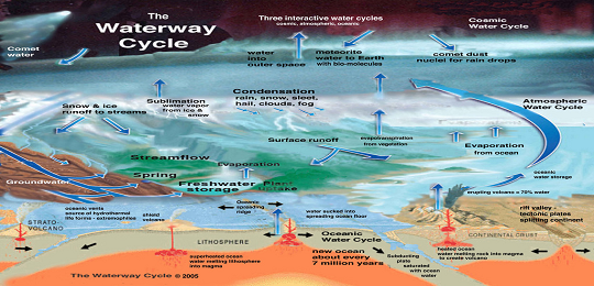
If the requests are approved by DWR, the unadjudicated “fringe areas” of the two groundwater basins will no longer need to be managed by the county under the Sustainable Groundwater Management Act (SGMA) if they are either excluded from the basin or reprioritized as low or very low. Follow www.slocountywater.org/sgma/ to sign up for the SGMA email list.
